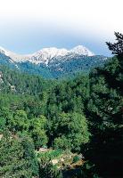
 Coniferous forests (pines and firs) in the
middle zone of mount Taygetos East of Kalamata, in the middle of Messinia and Laconia districts, stands the imposing and magestical Taygetos, the tallest mountain of Peloponnese. The rare flora and fauna of the area, the picturesque villages on the slopes of the mountain (some of them belong to the Municipality of Kalamata) and the beautiful gorges offer the hikers a unique experience. Having as a starting point some of the villages of the Kalamata Municipality, you may enjoy the hiking routes in the mountain of Taygetos. Lagou Hani – Velanidia Monastery – Kalamata
Duration: 6.45h
We set off from Kalamata and at the 18th kilometre of the Kalamata - Sparta Highway turn off towards the village of Nedousa. Our trek begins shortly after we pass a bridge to reach Lagou Hani. The wooded path begins just a few meters after the bridge, winding its way up towards Limnatida. Here we see another path, which is clearly marked and not very steep, and offers a nice view of the surrounding area. The Nedontas River is below and the highway climbs Taygetos across the way. 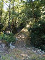 Lagou Hani – Velanidia Monastery – Kalamata The highest part of the path does not afford us a view of the river or the road, and while it takes a few confusing turns, it eventually leads us back to the river. The walk along here is pleasant, without sharp inclines. Passing by a goat shed, we reach the Velanidia Monastery. This is a good place for a short break. We continue down the faded path, which is traversed by roads, to Nea Agora and the Kalamata coach station. Cars can also be left at the monastery. Lagou Hani - Alagonia
Duration: 2.30h
Starting from Lagou Hani, we head in the opposite direction from the city down the road leading to the village of Alagonia. We follow the bank of Nedontas River past the church to reach the beginning of the path. The landscape is stunning and the path takes us across four stone bridges, relics of a different era. The path climbs up the hill to the outskirts of Alagonia. The village is a good place to eat and rest. To return to Kalamata, use the same route or take public transport.  The village
of Nedousa Pano Karveli – Ladas – Taygetos Visitors’ Center
Duration: 5h
Just before the village of Karveli there is a distinctive spring at the side of the road. This marks the beginning of our trek. There is a small road leading into the woods across from the spring, which takes us down to the creek of Karveli. After approximately 15 minutes we find ourselves at a stone bridge which connects the villages of Pano Karveli and Emialos. The spot here is spectacular! Early in spring the creek runs high, its gurgling waters accompanying the bird song in a magical symphony! We continue our walk up a gentle slope leading to the village of Ladas. A small detour through Emialos brings us to Ladas, where we can have a snack and something to drink. We continue our walk through the village, climbing past the last houses of the village, walking briefly along a stretch of road and heading west past Mount Aghios Georgios. Alternating between the mountain path and the road for approximately 1 hour and 45 minutes we reach the Kalamata – Sparta Highway. We cross the street to the continuation of the path on the other side. A 20-minute walk will loop us back to the highway, about 2 kilometers from the visitors’ center. 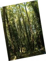 Lagou Hani - Alagonia Pano Karveli – Kato Karveli
Duration: 3.30h
Starting again from the spring of the previous route, we climb up the steep, but short, slope behind the spring for about 5 minutes until we come across the path that connects the two villages. The path is very well marked and affords a good view of the surrounding landscape. From its highest point one can see all the way to the sea and enjoy a vista of tree tops. Following the path downhill brings us to Kato Karveli. A 1,5-kilometer dirt road leads us from the village back to the Kalamata - Sparta Highway, which we take back to the city – after having had a refresher at the village, of course. 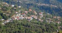 The village
of Alagonia Kato Selitsa (Verga) – Profitis Ilias (1.300 m.)
Duration: 4.15h
The village of Selitsa (also known as Verga) is located 7 km from Kalamata. A stone-paved path begins at the very top of the village, climbing up the western side of the mountain. A 2-hour trek along this path, which takes us past a small picturesque chapel, brings us to Pano Selitsa. The village is very sparsely populated, especially in winter. The village has a small natural spring, where one can replenish water supplies for the rest of the hike up to the Church of Profitis Ilias. The village also has a snack bar on the main square. The path continues past the last houses of the village, sloping gently down towards the fringe of the woods of fir trees. The view here is enchanting – the Messinian Gulf lies at our feet, its clean beaches glistening in the sun. Continuing down the path brings us to a spot dubbed by locals as “Portes” (or gateway), which leads into the heart of the woods. Shortly after Portes, the path heads south and up to the Church of Profitis Ilias. This 1-hour stretch crosses by a wooded road that leads to Pano Selitsa. Just south of Profitis Ilias there is small natural plateau known as the “Balcony”, where one can have a rest and enjoy a wonderful view of the landscape, stretching from the highest peaks of Mount Taygetos down to the lovely Messinian coastline. One can return along the same route. 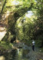 The stone
bridge in the
Karveliotiko
creek 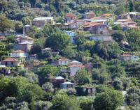 The village
of Ladas
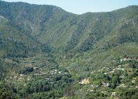 Karveli |